Enregistrez gratuitement cette image
en 800 pixels pour usage maquette
(click droit, Enregistrer l'image sous...)
|
|
Réf : T01623
Thème :
Terre vue de l'espace - Villes (375 images)
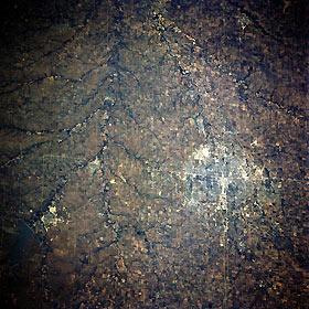
Titre : Wichita and Flint Hills, Kansas, U.S.A. October 1993
Description : (La description de cette image n'existe qu'en anglais)
Wichita and the grass-covered, rolling terrain of the Flint Hills to its east are featured in this south-looking, low-oblique photograph. Wichita, the chief commercial and industrial center of southern Kansas, was founded in 1868 by settlers serving the famed Chisholm Trail and became a boom town in the 1870s and 1880s as a trade center for livestock and agriculture. Oil was discovered in the Flint Hills in 1915. An important aircraft manufacturing center, Wichita also has railroad shops, flour mills, meat packing plants, grain elevators, oil refineries, heating and air conditioning plants, pharmaceuticals manufacturers, printing plants, and stockyards. Several manmade features are discernible—north-south-oriented Interstate Highway 35; runways of McConnell Air Force Base southeast of the city; and El Dorado and El Dorado Reservoir to the northeast. The Arkansas River is barely discernible flowing south-southeast from Wichita.
|
|

